

January 1st came quickly. A new big green big year! Getting up early after New Year's Eve was tough, but I was out walking in my small-town residential neighborhood listening for owls and any other vocal birds at 5:45. Except for the "swish" of a Barn Owl, a Black-crowned Night Heron "skwaack", and a distant Killdeer whistle, it was quiet. I thought that a black cat had closely crossed my darkened path as I neared home, but I realized when its tail went up and I could see some white on the back that this was a creature that could truly bring bad luck! I retreated quickly, but this may have been an omen for the day to come.
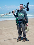
After a breakfast and a last check of my bike I walked the barely light neighborhood with my dog, my scope and my binos. The already high tide told me I would have to really scramble to get the shorebirds I needed before the 10:00 AM 6.7 foot high tide. I did manage to find 65 avian species along the edge of Cuesta Inlet with the highlight being an Osprey. I then went back home to get on my bike and have Celeste take the above photo.
My bad luck began when I tore a ligament in a finger while loading my bike and started on the road just after 8:00 with one finger that would not straighten. I checked the nearby golf course where three species of geese had been and none were there this morning! I briefly stopped at several bayside locations to look for waterfowl and shorebirds, but I realized about an hour of the way into my trip that my bike's rear axle was making weird noises. I kept heading north: hoping the noise would go away. I stopped briefly at the Elfin Forest to check the coastal scrub for thrasher, quail, Fox Sparrow and gnatcatcher. As I continued around the bay, the tide got so high that shorebirds were no longer at the bay's edge because the it was flooded by the incoming tide. I did manage to find the rusty head of a male Eurasian Wigeon in with all the Americans - in the flooded pickleweed. A fluffed-up young Peregrine perched on a low snag was making the Willets and godwits nervous as they huddled up on high spots to escape the in-rushing tide.
I made a careful search of the Morro Bay Sate Park Marina peninsula, looking for Sharp-tailed Sparrow and Large-billed Savannah Sparrow but saw none amongst the usual Savannah Sparrows that were running around just above the tide. The above Long-billed Curlew was working the edge with Greater Yellowlegs and Willets, seemingly little concerned about me.
I stopped a couple of times to scan the bay from overlooks on Bayshore and Olive Streets and stopped at Morro Rock where I scanned the ocean and ate my lunch. Black-vented Shearwaters and Common Murres flew by, along with Red-throated and Pacific Loons, cormorants, terns, and gulls.
North of Morro Bay is North Point which can be good for scoping the ocean and I did manage to find a White-winged Scoter with the Surf Scoters there. Surbirds and Black Turnstones flew around the rocks below my perch, evading the surf.
I continued north on my bike and so did the rear axle noise, which was getting worse. Should I keep going north up the coast on my bike, to camp well away from any town? Or should I turn around and return home at some point? I decided to bird more thoroughly and locally to cut down my mileage - I only went about 15 or 20 miles to the north and turned around. During the course of the trip I also realized that I was packed way too heavy (see picture above)and that all the weight on the rear of the bike made the bike unbalanced. The panniers (front and rear) that I had ordered would have helped with the balance, but I was carrying way too much optical gear - full sized Zeiss binos, an SLR camera with telephoto and wide-angled lenses, a large Zeiss scope and a tripod. My 2-man tent and sleeping bag were fine for backpacking, but not biking. (It turned out that I had a broken axle and a cracked hub on the rear wheel so it was good I turned around. After replacing my rear wheel, getting a new chain and cables, and having other routine maintenance, I am good to go for future trips.)
On the way home I stopped at more coastal locations. The day was comfortable in the mid-sixties and the wind was at my back as I pedalled south. I filled in some gaps of common species along the coast and my day's total was 122 species for January 1 - not what I had hoped for, but decent. I got a few must see winter species ticked off my list, but missed some rarities known to be present such as the 2 sparrows. I learned some lessens about bike touring as well - pack light, balance the load, and have your biked checked over by a good bike mechanic periodically if you plan to do multi-day trips. I still have to put my birds on eBirds and plan for the rest of the month's bike-birding.
Today's BIGBY route fro Los Osos to Cayucos (all by bike unless it says otherwise) was: 1)Walk Cuesta-by-the-Sea (Nancy to Pecho, along the bay, and adjacent residential area),2)Sea Pines Golf Course to check the 2 ponds from Howard, 3)Bay access at Mitchell and Doris, 4)Sweet Springs Nature Reserve on Ramona, 5)along the bay edge and to Baywood Pier on Second, 6)left on Pasadena Drive (check overlooks) to the Audubon Overlook at the end of Pasadena (very end of gravel part),7)Santa Ysabel to the overlook at end of Seventh, 8)Elfin Forest from the end of 13th (off Santa Ysabel)and check feeder at house at end of 13th, 9) South Bay Blvd.(best at 5 - 6 foot incoming tide) and ponds along the bay end of Turri Road, 10)Morro Bay State Park Marina on State Park Road and the edge of the bay from the bay side of the marina (6' high or higher tides are best), 11)Overlook on Bayshore (left off Main), 12)Overlook from the bay end of Olive, 13)Down Marina to Embarcadero and bird out to Morro Rock, 14) mouth of Morro Creek at the end of Embarcadero (where it is dirt where Coleman turns toward the Rock), 15) bike path off Main near Lemos Feed Store past Lila Kaiser Park, 16)bike path past Morro Bay High to the Cloisters Pond, 17)Sandlewood and Beachcomber along Atascadero Beach to Yerba Buena (scan beach) and left on Toro Lane before Highway 1 to North Point (scope from the dirt path above the parking), 18)Studio Drive to Old Creek Road to Whale Rock Reservoir (best birding is usually in the back along Cottontail Creek Road, 19)Back to Studio Drive to its north end and the creek mouth, 20)Take Cabrillo on the other side of Highway 1 through the cemetery and into Cayucos on 13th to Pacific, 21) ride along the coast to the Cayucos Pier (check if birds near end), and 22)the rocky shore from North Ocean Avenue to Highway 1.


No comments:
Post a Comment